
GPS Mapping

GPS Mapping technology provides accurate drain layout maps

GPS Mapping is essential when carrying construction works on a building or site to have detailed drawings of the current drainage layout. We at CES Environmental Services provide our client with detailed drawings of all foul and storm lines, manholes, gullies with GPS coordinates.

If you would like to find out more about our GPS Mapping Services, or any other services
Talk to us:

GPS-Mapping Process

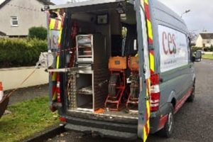
Our highly experienced Engineers use the most up to-date CCTV cameras with Wincan V8 and Sonde Transmitter to locate the drainage network. We also use a Trimble TDC 100 to provide accurate GPS co-ordinates – this will also provide photos of each point. Our Engineer then produces a drawing, report and DVD footage of the drains.

Our finished GPS-mapping report will also highlight any issues or faults in the drainage network. This will ensure that our client can move forward with full knowledge of their drainage network and its condition.

CES Engineers Checking Drainage Drawings for accuracy

GPS-Mapping FAQ

What is GPS drainage mapping?

GPS drainage mapping uses GPS technology to precisely record the location of underground drainage assets — including manholes, pipe runs, inspection chambers and outfalls — and produce accurate maps for use in GIS systems or engineering drawings.

Who uses GPS drainage mapping?

GPS mapping is used by local authorities, Irish Water, property developers, civil engineers and facilities managers to create or update drainage asset registers, support planning applications and manage infrastructure maintenance.

Other Services

Scroll to Top